 |
Package includes: |
-
GPSMAP 276C
-
One basemap below
Americas:
►Americas Autoroute
Europe:
►Atlantic Autoroute
-
USB-PC interface cable
-
Power/data cable
-
Marine mount
-
Rechargeable lithium battery pack
-
AC adapter
-
Trip & Waypoint Manager CD
-
Manual
-
Quick-start guide
Optional automotive kit:
|
|
 |
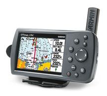
GPSMAP 276C
The GPSMAP 276C is an all-in-one, versatile, color
chartplotter and automobile navigator — perfect for land
or water. This portable GPS navigator features a 256-color
TFT display that's easy to read in bright sun along with a
built-in basemap and auto routing to provide you with
turn-by-turn directions to the marina for a day of
boating.
On water, the GPSMAP 276C is a dependable, color
chartplotter with a built-in Autoroute basemap enhanced by
Garmin's marine cartography. It accepts pre-programmed or
user programmed data cards with MapSource® BlueChart® for
offshore detail or Recreational Lakes with Fishing Hot
Spots® for detail of inland lakes.
In addition, the GPSMAP 276C supports external NMEA
sources for water depth, water temperature, and water
speed through two serial interfaces. The unit also
features a new Course Deviation Indicator (CDI) — an
advanced navigation tool commonly found on aircraft, but
equally practical in the marine environment. The CDI
quickly indicates if a boat has veered off course.
On land, the GPSMAP 276C’s Americas or European Autoroute
basemap features interstates and major highways. With an
optional automotive kit that includes MapSource City
Select® software, data card, friction mount, and 12-volt
power adapter with speaker, drivers can receive
voice-prompted turn-by-turn directions to addresses and
points of interest throughout the United States and Canada
or Europe.
For map transfer or software updates, the GPSMAP 276C
features a fast USB-PC interface. The unit is also powered
by a rechargeable lithium-ion battery pack, or a standard
110-volt AC plug
Don't pay retail prices! Contact us before you
purchase.
|