 |
Package includes: |
-
GPSMAP 60C
-
One basemap below*
Americas:
►Americas Recreational
Europe:
►Atlantic Recreational
Australia:
►Pacific Recreational
-
MapSource® Trip & Waypoint Manager CD
-
PC/USB interface cable
-
Lanyard
-
Belt clip
-
Quick
Start Guide
-
Owner's manual
*Americas version for sale only in North America;
European version for sale only in Europe; Australian
version for sale only in Australia.
|
|
 |
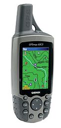
GPSMAP 60C & 60CS
The GPSMAP® 60C and GPSMAP 60CS
are new all-purpose units—packed with exciting new
features and delivering the kind of color that consumers
want in their handheld GPS’s. These lightweight, rugged,
waterproof units raise the bar to offer a 256-color,
highly reflective display that provides easy viewing in
almost any lighting condition. This transreflective TFT
technology provides excellent viewing while maximizing
your battery life (30 hours, typical use).
Both the GPSMAP 60C and GPSMAP 60CS are packed with extra
features, including rapid automatic route calculation, an
integrated outdoor calendar, a dedicated geocaching mode,
and indoor/outdoor GPS games that turn the outdoors into a
giant gameboard.
GPSMAP 60C Features:
-
Sunlight-readable display with 256-color transreflective
TFT display (1.5" W x 2.2" H; 2.6" diagonally); color
operating system with new look-and-feel
-
Faster processor, with auto routing, turn-by-turn
directions, and audio alerts along city streets or trails
when using MapSource® City Select® or 24K Topo software
(optional software)
-
56 MB of internal memory for storing map detail
-
Permanent user data storage
-
Each day’s best hunting and fishing times—along with
sunrise/sunset times—on the integrated Outdoor Calendar
-
Special geocaching navigation mode
-
Geolocation games, such as Virtual Maze, Nibbons, Geko™
Smak, and Memory Race
-
Fast map transfer, with support for both USB and serial
port interfaces; navigation instructions can be shared
with repeaters, plotters, and autopilots using NMEA
protocols through the dedicated serial port
-
Detailed basemap with general map data, including
highways, major roads, river, lakes, and borders
-
Dedicated "mark", "page", "enter", "quit", "menu", "find",
and "zoom out/in" buttons; four-position rocker pad
-
2.4" x 6.1" x 1.3" (W x H x D) unit dimensions
-
Weighs 5.4 ounces (without batteries), 7.5 ounces (with
batteries)
-
WAAS GPS receiver with accuracy to 10 feet in North
America; built-in quad-helix antenna for better satellite
reception
-
30 hours of battery life under typical-use conditions
(uses two "AA" batteries)
-
Multi-platform navigation for easy navigation in a car or
boat, or on foot
-
Accepts data from MapSource products (City Select for
driving, U.S. Topo and 24K Topo for hiking, Recreation
Lakes for freshwater, and BlueChart® for saltwater
applications)
-
Waterproof to IEC 60529 IPX7 standards (can be submerged
in one meter of water for up to 30 minutes)
-
50 reversible routes, 10,000 track points with tracBack®
technology (navigate to any track point on the displayed
map), and 1000 waypoints with additional graphical icons
for location identification
-
Proximity alerts for anchor drag, arrival, off-course,
proximity waypoint; built-in alarm clock
-
User-configurable track-line color, waypoint projection,
display color scheme, large-numbers option, audio tones,
and pages (turn on/off main pages or change the sequence
in which they appear)
-
Trip computer provides odometer, stopped time, moving
average, overall average, total time, max speed, and more
Don't pay retail prices! Contact us before you purchase.
|