 |
Package includes: |
|
|
 |
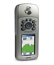
GPSMAP® 76C & 76CS
All other marine
handheld GPS units pale when compared to the GPSMAP 76C
and GPSMAP 76CS—literally.
The latest color-display technology gives both units
the brightest, sunlight-readable displays available. And
with brand-new state-of-the-art receivers and powerful
microprocessors, these units will give you a quick and
steady fix.
Both the GPSMAP 76C and GPSMAP 76CS have the familiar
GPS 76-family keypads and styling, with 115 MB of memory,
an Americas Autoroute basemap, and a Marine Point
database. Fast USB connectivity makes loading charts and
maps quick and easy, while navigation instructions can be
shared with repeaters, plotters, and autopilots using NMEA
protocols through the dedicated serial port.
They’re waterproof and fully compatible with MapSource
products like BlueChart®, U.S. Topo 24K, and City Select®
(which provides detailed streets for turn-by-turn
guidance).
GPSMAP 76CS Features:
-
Built-in quad-helix antenna with remote antenna
capability
-
Electronic compass displays accurate heading while
standing still
-
Barometric sensor with automatic pressure trend
recording
-
Elevation computer provides current elevation,
ascent/descent rate, minimum/ maximum elevation, total
ascent and descent, average and maximum ascent and
descent rate
-
115-MB internal memory for loading MapSource detail,
including marine cartography
-
USB connectivity for quick chart and map downloads
-
6.2" H x 2.7" W x 1.4" D unit dimensions
-
Sunlight-readable display with 256-color
transreflective TFT display (1.5" W x 2.2" H; 2.6"
diagonally); color operating system with new
look-and-feel
-
Weighs 7.6 ounces (with batteries)
-
LED-backlit display and keypad
-
Up to 20 hours battery life (uses two AA alkaline
batteries)
-
Permanent user-data storage; no memory battery
required
-
Includes a built-in
Americas Autoroute basemap with auto-routing
capabilities, including highways, exits, and tide data
(U.S. only)
-
Internal memory is pre-loaded with a
Marine Point database
-
Water resistant to
IEC 60529 IPX7 standards (can be submerged in one
meter of water for 30 minutes); rugged and waterproof
housing that floats
-
1000 user waypoints with name and graphic symbol; 50
reversible routes
-
Position formats include Lat/Lon, UTM, Loran TDs,
Maidenhead, MGRS, user grid, and more
-
Audible alarms for anchor drag, arrival, off-course,
proximity waypoint, and clock
-
Large-numbers option for easy viewing; dual-position
display mode
-
Trip computer provides odometer, stopped time,
moving average, overall average, total time, max speed,
and more
-
10,000 point automatic track log; 20 saved tracks
let you retrace your path in both directions
-
Built-in celestial tables for best time to fish,
plus sun and moon calculations
-
Compatible with most MapSource products including
BlueChart,
City Select,
U.S. Topo 24K,
U.S. TOPO, and Recreational Lakes with Fishing Hot
Spots
Don't pay retail prices! Contact us before you purchase.
|